


Mapping plastic pollution in water from space: potential opportunities and challenges for the application of NASA’s PACE mission
 0
0 Abstract
Marine plastic pollution is an escalating global concern, yet accurate data on aquatic plastic debris remain scarce due to the inherent limitations of traditional in situ sampling methods. To address this gap, next-generation hyperspectral satellite missions, particularly the Plankton, Aerosol, Cloud, Ocean Ecosystem (PACE) mission of the National Aeronautics and Space Administration (NASA), offer promising potential for monitoring plastic pollution. This review applies narrative and scoping approaches to evaluate the potential utility of PACE in aquatic plastic monitoring. Drawing on 100 curated references, it examines 10 key studies employing Sentinel-2, Landsat-8, WorldView-2 and -3, the Hyperspectral Precursor of the Application Mission (PRISMA), Sentinel-3, and the Environmental Mapping Analysis Program (EnMAP), providing insights relevant to PACE’s hyperspectral capabilities. Key mission parameters - including spatial resolution, spectral granularity, temporal revisit cycles, and polarimetric sensitivity - are compared across platforms. A post-hoc design suitability assessment and a structured Strengths, Weaknesses, Opportunities, and Constraints (SWOC) analysis of PACE’s instruments highlight both advantages and limitations for aquatic plastic monitoring. The review proposes targeted strategies such as spectral unmixing, correction for confounding absorption effects, and derivative reflectance analysis to enhance the detection of plastic signals in optically complex waters. Although empirical evidence remains limited, this review argues that PACE’s unique architecture - combined with multisensor data fusion and advanced analytical methods - has the potential to overcome current methodological constraints. It presents a testable hypothesis that PACE’s spatial, spectral, and polarimetric capacities can significantly advance satellite-based monitoring of aquatic plastic pollution.
Keywords
INTRODUCTION
Plastics are recalcitrant, ubiquitous, and allochthonous emerging pollutants in aquatic environments, introduced from external sources and characterized by their persistence and widespread global use. Increasing global plastic production now exceeds 460 million tonnes annually, and unsustainable practices such as mass production, urban runoff, and inadequate waste management contribute to an estimated 1.7 million tonnes of plastic entering the oceans each year[1-4]. This growing influx poses a persistent threat to marine ecosystems, disrupting biodiversity and ecological health on a global scale, but many of the effects are not yet fully understood[5]. Despite the growing availability of data on global plastic production and mismanagement[1,2], spatially resolved information on pollution hotspots in inland and coastal waters remains critically limited[6,7]. Consequently, evaluating the effectiveness of policy interventions such as the 3Rs (reduce, reuse, recycle) and accurately quantifying pollution impacts remains a significant challenge.
Current monitoring approaches rely primarily on in situ sampling and laboratory analyses, which are resource-intensive and costly, thus limiting their spatial and temporal coverage[8]. This data gap hinders the development of effective interventions and policy frameworks for mitigating plastic pollution. To address these challenges, next-generation monitoring methods using satellite missions equipped with advanced multispectral sensors have emerged as promising tools for enhancing the spatio-temporal detection of plastics in aquatic environments. Frequently used sensors include Sentinel-2’s MSI[8-24], WorldView-3[8,25-31], and the OLI sensor aboard Landsat-8[32,33].
However, multispectral sensors offer limited spectral resolution, and several plastic-sensitive wavelengths are notably absent, constraining their ability to reliably detect and differentiate diverse polymer types. To overcome these limitations, researchers are increasingly turning to hyperspectral satellite missions such as Hyperspectral Precursor of the Application Mission (PRISMA)[34,35]. By capturing data across hundreds of contiguous spectral bands, PRISMA enables precise detection and discrimination of various plastic polymers based on their unique spectral reflectance signatures. This high spectral resolution is particularly advantageous for identifying subtle differences among plastic types and distinguishing them from natural organic materials in aquatic environments.
Despite these benefits, several operational limitations remain. Given the enormous stretch of global oceans, the widespread coverage of coastal zones, and the sheer volume of satellite data required for consistent monitoring, traditional remote sensing workflows quickly become impractical. Processing such large datasets is computationally expensive and time-consuming, requiring substantial human and technological resources - challenges further amplified by the dimensional complexity of hyperspectral imagery. In this context, the integration of machine learning (ML) techniques with Earth observation (EO) data has emerged as a promising solution to overcome these barriers[14-24,27,34,35].
At the same time, an expanding body of interdisciplinary literature - including seminal contributions by Salgado-Hernanz et al. (2021)[36], Mukonza and Chiang (2022)[37], Park et al. (2022)[38], Veettil et al. (2022)[39], Ma et al. (2023)[40], Goddijn-Murphy et al. (2024)[41], and Chabot and Marteinson (2024)[42] - has examined the utility of multisensor platforms such as satellite constellations, unmanned aerial vehicles (UAVs), and LiDAR systems for monitoring aquatic plastic pollution. These studies highlight the complementary strengths of different observational technologies in detecting surface plastics under diverse environmental conditions. However, much of this work remains exploratory in nature, often adopting broad, multi-platform perspectives that lack a deep engagement with the operational feasibility, spectral specificity, or sensor design constraints of individual systems. While valuable for hypothesis generation, this generalist approach leaves a gap in understanding the viability of specific missions for sustained, large-scale monitoring.
Addressing this gap, the present review adopts a feasibility-oriented perspective focused explicitly on National Aeronautics and Space Administration (NASA)’s Plankton, Aerosol, Cloud, Ocean Ecosystem (PACE) mission. We synthesize existing literature on satellite-based plastic detection and assess how PACE’s hyperspectral and polarimetric sensor suite including the Ocean Color Instrument (OCI), the Hyper-Angular Rainbow Polarimeter-2 (HARP2), and the Spectro-Polarimeter for Planetary Exploration (SPEXone) might help overcome long-standing detection and characterization challenges in global aquatic plastic monitoring.
PACE represents the most advanced global ocean color mission to date, offering a multi-instrument observational platform capable of monitoring oceans, large inland lakes, and coastal zones. The hyperspectral capabilities of OCI, originally designed to distinguish phytoplankton communities and pigment signatures, may also enable the discrimination of a wide range of plastic polymers in aquatic systems, which includes, but are not limited to, high-density polyethylene (HDPE), low-density polyethylene (LDPE), polypropylene (PP), polystyrene (PS), polyethylene terephthalate (PET), polyester (PE), nylon, natural rubber (NR), cellulose acetate, and ethylene vinyl acetate (EVA)[43]. Furthermore, PACE’s polarimetric instruments - HARP2 and SPEXone - offer advanced spectro-polarimetric capabilities for detecting water surface features by capturing the polarization signatures of reflected sunlight[43]. Collectively, these instruments advance the ability to detect and discriminate surface anomalies in complex aquatic environments, including floating plastics, oil films, and other particulate matter.
Although OCI is not explicitly configured for direct detection of macro-, meso-, micro-, or nanoplastics due to their small size and complex optical properties, PACE offers a rich suite of ocean color products, including chlorophyll a (Chl a), particulate organic carbon (POC), colored dissolved organic matter (CDOM), diffuse attenuation coefficients (Kd), spectral phytoplankton and non-algal particle absorption coefficients (aph and adg), particle backscattering coefficients (bbp), normalized fluorescence line height (nFLH), photosynthetically available radiation (PAR), remote sensing reflectance (Rrs), apparent visible wavelength (AVW), Multiple Ordination ANAlysis (MOANA), and surface reflectance (Lλ), among others[44-46]. When integrated with ML algorithms and data fusion techniques, these products provide indirect spectral signatures and environmental proxies to infer the presence and spatial distribution of plastics in surface waters. This approach reflects a broader precedent in remote sensing, where satellites have demonstrated unforeseen capabilities beyond their original design, such as monitoring cholera outbreaks[47], economic progress[48], wildlife migrations[49], and illicit fishing[50]. Building on these insights, the objective of this study is to evaluate the potential utility of PACE for plastic pollution monitoring and inform the design of future satellite missions optimized for detecting plastics in aquatic environments.
SPECTRAL AND STRUCTURAL DESIGNS OF PACE SENSORS AND THEIR IMPLICATIONS FOR AQUATIC PLASTIC MONITORING
To address global challenges such as plastic pollution in aquatic systems, NASA’s PACE mission is equipped with a suite of cutting-edge hyperspectral optical and polarimetric instruments [Figure 1][51]. These include the OCI, the HARP2, and SPEXone, each designed to provide complementary spectral and angular observations crucial for surface water monitoring and material discrimination[52-55].
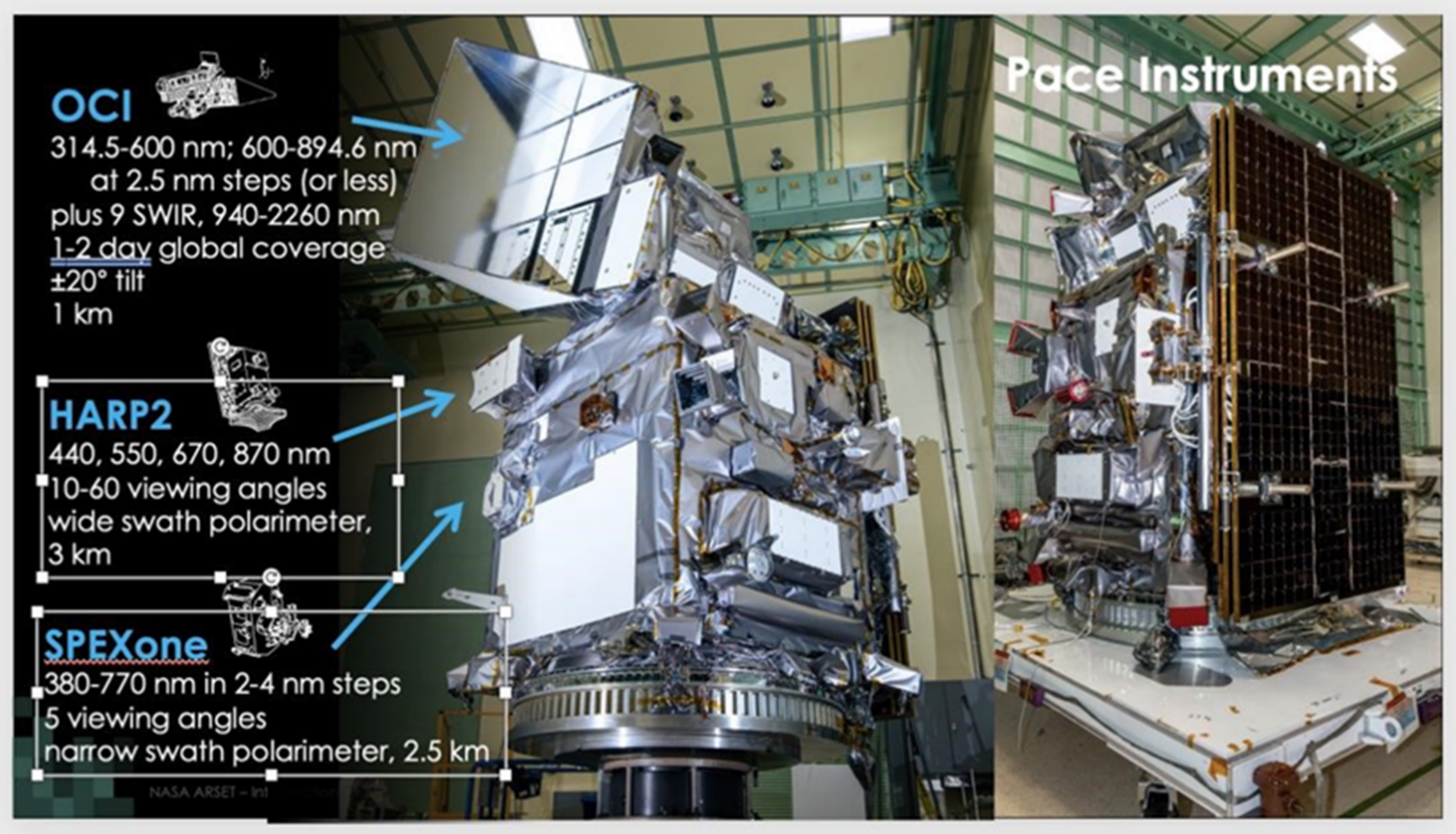
Figure 1. An annotated photograph of NASA’s PACE satellite mission payload showing the three primary instruments: OCI, HARP2, and SPEXone. These instruments collectively provide hyperspectral and multi-angle polarimetric observations critical for monitoring ocean ecosystems, aerosols, clouds, and potentially plastic pollution in aquatic environments. (Image source: NASA PACE)[51]. NASA: National Aeronautics and Space Administration; PACE: Plankton, Aerosol, Cloud, Ocean Ecosystem; OCI: Ocean Color Instrument; HARP2: Hyper-Angular Rainbow Polarimeter-2; SPEXone: Spectro-Polarimeter for Planetary Exploration.
• OCI (top): Provides hyperspectral observations from 314.5-894.6 nm in 2.5 nm steps, plus 9 short-wave infrared (SWIR) bands from 940-2,260 nm, enabling global ocean color measurements with ±20° tilt and
• HARP2 (middle): A wide-swath imaging polarimeter measuring at 440, 550, 670, and 870 nm across 10-60 viewing angles, with 3 km ground resolution[52-55].
• SPEXone (bottom): A narrow-swath polarimeter measuring 380-770 nm in 2-4 nm steps, with 5 angular views and 2.5 km resolution[52-55].
A critical innovation in OCI’s SWIR subsystem is its 16 × 1 micro-lens array, which projects the entrance slit scene onto an array of fiber-coupled InGaAs and HgCdTe photodiodes, each precisely filtered to defined spectral bands[52-55]. This optical-electronic architecture enhances spectral sensitivity in the SWIR domain, where numerous plastic polymers display distinct reflectance features, facilitating their remote identification[52-55]. However, intrinsic carrier diffusion within the semiconductor layers of these photodiodes induces a characteristic “slow tail” in the temporal pulse response, leading to signal persistence and spatial-spectral cross-talk across adjacent pixels - an effect that can degrade the spatial fidelity and spectral discriminability of small or low-contrast plastic debris[52-55]. The severity of this artifact depends both on the diode material properties and on the upstream optical coupling design. To mitigate these distortions, OCI employs advanced detector response correction algorithms that model and subtract impulse broadening effects, thereby preserving the spectral purity and spatial precision essential for robust detection and classification of marine plastics in complex oceanic radiance fields.
Additionally, the advent of optical hyperspectral imaging in OCI represents a paradigmatic shift from the quantized, band-limited capabilities of heritage multispectral sensors toward a continuous spectral formulation, where each 5 nm increment becomes a resolvable degree of spectral freedom [Figure 2][51,56]. This transition from discrete to quasi-continuous spectral sampling transcends legacy pigment and aerosol retrieval schemes, providing a spectroscopically richer Hilbert space for remote detection[56]. For plastics monitoring, this finer resolution permits the disentanglement of overlapping absorption features through identification of functional group structures, pigment coloration, and fluorescent signatures, to discriminate and identify polymer-specific spectral fingerprints, and correction of atmospheric interferences, all within a unified spectral calculus[57,58]. In essence, OCI replaces the coarse sampling of multispectral systems with a finely resolved spectral continuum, offering a more complete basis set for inverting the complex reflectance of ocean surface plastics and associated biogeochemical phenomena. Such spectral granularity facilitates the precise differentiation of phytoplankton functional types, characterization of CDOM, and detection of anomalous reflectance signatures indicative of marine plastics.
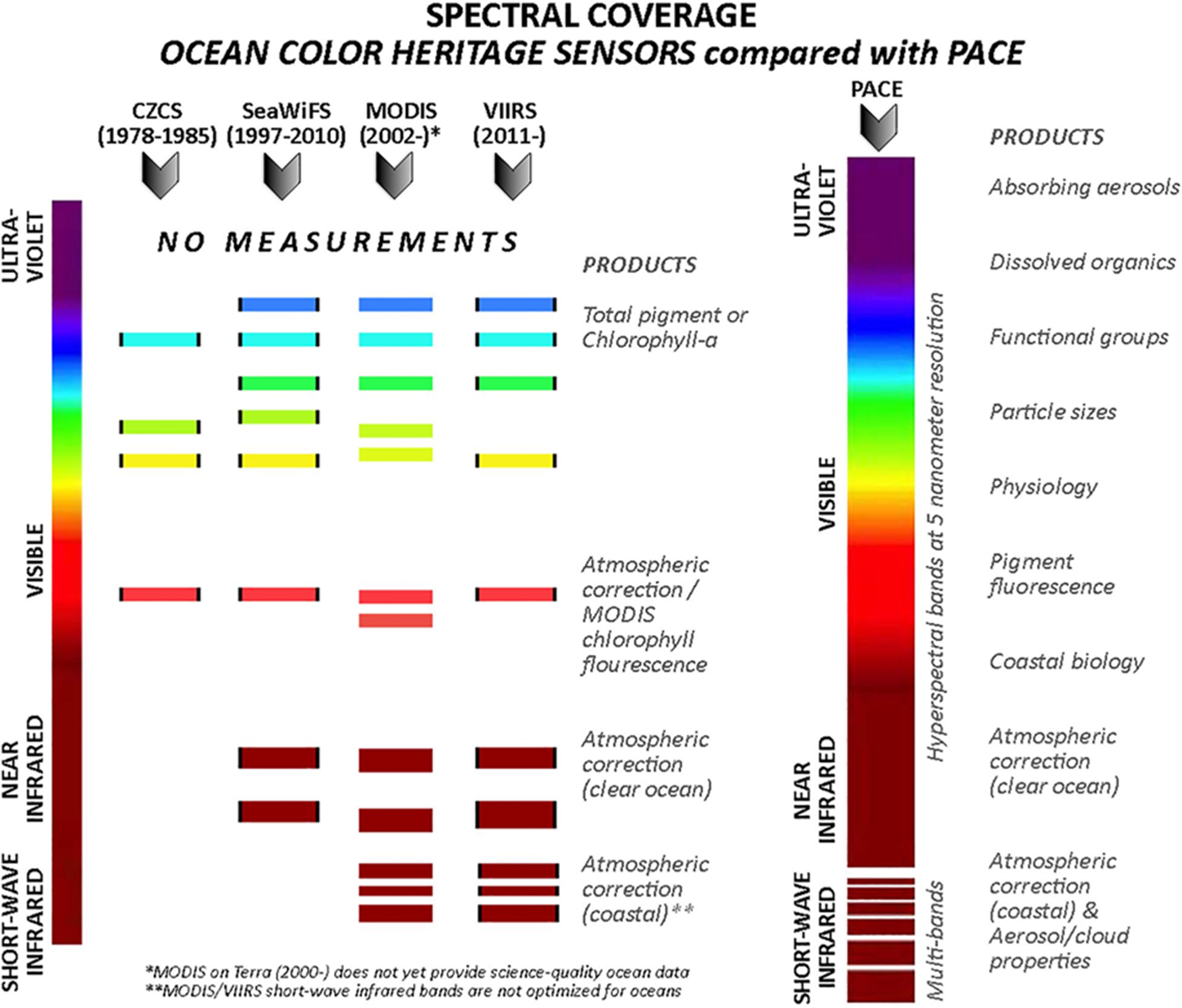
Figure 2. Comparative spectral coverage and resolution of ocean color heritage sensors (CZCS, SeaWiFS, MODIS, VIIRS) versus NASA’s PACE mission across UV-VIS-NIR-SWIR wavelengths (Image source: NASA PACE)[51]. NASA: National Aeronautics and Space Administration; PACE: Plankton, Aerosol, Cloud, Ocean Ecosystem; UV-VIS-NIR: ultraviolet-visible-near-infrared; SWIR: short-wave infrared.
The combination of HARP2 and SPEXone aboard NASA’s PACE mission represents an advanced synergistic polarimetric sensing suite, engineered to quantify the polarization state of sunlight scattered by the Earth’s surface and atmosphere, enabling the retrieval of aerosol optical properties, water-leaving radiances, and refractive index perturbations at the air-sea interface[59-61]. SPEXone is a high-precision spectropolarimeter that measures the degree and angle of linear polarization (DoLP and AoLP) in hyperspectral detail across a single-viewing geometry, with particularly high fidelity in the SWIR domain. This makes it sensitive to subtle refractive index discontinuities in the ocean’s microlayer, potentially signaling hydrophobic pollutants such as oil films or plastic debris[59-61]. By contrast, HARP2 employs a wide-swath, multi-angle imaging polarimetry strategy, capturing up to 60 discrete angular observations per scene across blue to near-infrared bands, enabling angular-dependent polarization analyses that disentangle surface roughness effects and enhance sensitivity to specular and diffuse reflectance signatures associated with buoyant plastics[59-61]. Through the application of Fresnel reflectance principles and statistical modeling, HARP2 facilitates robust refractive index retrievals that, when coupled with SPEXone’s spectral polarization granularity, create a powerful dual-instrument approach for deconvolving complex light-path interactions in the atmosphere-ocean system. The combined use of HARP2 and SPEXone establishes a unique spectroscopic framework for the remote sensing of aquatic plastic pollution. Their joint ability to retrieve ocean surface refractive indices even under sun-glint conditions, improve atmospheric correction, and detect microphysical particle properties significantly improves surface reflectance accuracy, enabling the reliable separation of anthropogenic films from natural variability and thereby supporting detection of plastics, oil spills, and phytoplankton in optically complex marine environments[62-64].
METHODOLOGICAL APPROACH
Review approach and conceptual framework
This review adopts a hybrid narrative–scoping methodology approach to explore and critically evaluate the potential application of NASA’s PACE mission for monitoring plastic pollution in aquatic systems[65,66]. Given that empirical studies on PACE’s plastic detection capabilities are currently sparse or absent, this work undertakes an exploratory assessment by systematically reviewing and synthesizing prior efforts involving other satellite sensors - notably Sentinel-2, Landsat-8, WorldView-3, PRISMA, Sentinel-3, and EnMAP. These platforms offer insights into spectral, spatial, and radiometric factors that are analogously relevant to PACE’s hyperspectral design. Through this synthesis, the review maps existing capabilities (scoping) and extrapolates technical feasibilities, methodological gaps, and potential performance outcomes (narrative prediction). The goal is not to empirically evaluate PACE but to project its relevance, challenges, and strategic opportunities for advancing the remote detection of plastic debris, particularly in light of its novel hyperspectral coverage and its anticipated contributions to EO science.
Research questions
The methodological approach was guided by the following research questions:
RQ1: What sensor specifications and capabilities of the NASA PACE mission are relevant to aquatic plastic detection (e.g., spectral, polarimetric, spatial characteristics)?
RQ2: What are the known spectral or radiometric features of plastics in water, and how do these align with the observable parameters of PACE?
RQ3: How effectively can NASA’s PACE mission detect and monitor plastic pollution in aquatic environments, in comparison to existing satellite sensors such as Landsat, World View, and Sentinel-2?
RQ4: What specific advantages do PACE’s design specifications offer for detecting a wide range of plastic polymers across diverse aquatic environments, including oceans, inland lakes, and coastal zones, given limitations identified in past reports?
RQ5: To what extent can the spectral, spatial, radiometric, and temporal characteristics of PACE be optimized to meet the detection requirements for plastics, oil spills, and other water surface anomalies in aquatic ecosystems?
RQ6: How can the integration of PACE data with data from past satellite missions inform the design and development of future satellite sensors tailored to monitor plastic pollution in aquatic environments?
RQ7: What are the primary limitations and challenges in applying PACE’s remote sensing technologies in complex aquatic environments, and how can these challenges be addressed in future missions?
Source identification and search strategy
A literature search strategy was developed to include three traditional peer-reviewed databases: Web of Science, Scopus, and Google Scholar. Additionally, grey literature and technical documentation were included, such as reports, white papers, mission briefs, workshop presentations, and sensor design documents from organizations such as NASA, the European Space Agency (ESA), the National Oceanic and Atmospheric Administration (NOAA), the Japan Aerospace Exploration Agency (JAXA), and relevant working groups such as the Committee on Earth Observation Satellites (CEOS), and the International Ocean Color Coordinating Group (IOCCG) was also included.
Boolean search strings combined keywords related to:
▪ Satellite mission names and sensor technologies (e.g., “Landsat-8”, “Sentinel-2”, “World View-3”, “SAR-1”, “PACE”, “OCI”, “hyperspectral”, “polarimetry”)
▪ Plastic detection (e.g., “marine debris”, “plastic litter”, “floating macroplastics”, “polymer reflectance”)
▪ Remote sensing techniques (e.g., “remote sensing”, “ocean color”, “floating debris detection”)
Inclusion criteria
Documents were included if they met at least one of the following criteria:
▪ Provided technical specifications of the PACE mission relevant to aquatic detection (spectral bands, Rrs, polarimetry)
▪ Discussed satellite-based detection of plastic pollution in aquatic environments using satellite remote sensing techniques
▪ Offered transferable methods or insights from other satellite missions
▪ Identified community or stakeholder needs related to space-based plastic pollution monitoring
Data charting and organization
Extracted sources were organized using a structured spreadsheet and managed in Zotero for referencing. Data were charted according to:
▪ Source type (peer-reviewed article, technical report, white paper)
▪ Platform/sensor discussed (e.g., PACE, Sentinel-2, Landsat-8/9, World View-2/3, PRISMA)
▪ Relevance to the PACE mission or plastic monitoring
▪ Key technical parameters (e.g., spatial resolution, spectral bands, signal-to-noise ratio, polarization)
▪ Conceptual contribution to future PACE applications
Synthesis and mapping
A thematic synthesis was conducted to identify and cluster findings across three emergent dimensions:
▪ Sensor Compatibility - assessing the spectral and spatial feasibility of plastic detection using PACE’s capabilities
▪ Methodological Transferability - exploring how techniques from existing missions could inform plastic detection with PACE
▪ Community Needs and Challenges - highlighting gaps in data, validation, and operational readiness for satellite-based plastic monitoring
FIELD VALIDATION MEASUREMENTS, ADVANCES, AND CHALLENGES FOR PACE PLASTIC DETECTION PRODUCTS
Robust validation of measurements, data, algorithms, and final models is a cornerstone of any remote sensing methodology, particularly for emerging applications such as plastic pollution detection from space[67,68]. Because of the inherent complexity of linking satellite-derived signals to the physical plastic properties, a detailed understanding of field validation strategies, recent advances, and associated challenges is critical to framing the remote sensing approach[44]. Following the description of the methodological framework, we therefore present a focused discussion of field validation techniques and considerations tailored to PACE’s plastic detection products. This framing underscores that validation is not merely an auxiliary step but an integral methodological pillar essential for algorithm development, performance assessment, and the reliable interpretation of satellite observations.
Accurate validation of satellite-based plastic detection requires the collection of coincident in situ and satellite observations, standardized measurement protocols, consistent terminology, and robust validation algorithms benchmarked against PACE’s hyperspectral reflectance products. For the NASA PACE mission, equipped with OCI, HARP2, and SPEXone, a key step is to establish a classification framework that links in situ measurements - such as polymer identification via microscopy, FTIR, or GC-MS, particle size analysis, and surface texture characterization - to the optical and thermal signals detectable from space, including reflectance spectra, polarization signatures, and thermal contrast[69]. Unclear or inconsistent terminology across the literature - for instance, conflating “marine debris” with “plastic debris” - can cause ambiguity in algorithm development and reduce classification accuracy[70].
To address this, it is essential to clearly define the scope and terminology of key marine pollutants, including marine debris, plastic debris, and non-plastic debris[70]. Marine debris includes all persistent solid materials introduced into the ocean, such as plastics, metals, glass, rubber, and textiles. Plastic debris refers to synthetic or semi-synthetic polymers, while non-plastic debris includes materials such as wood, metal, and glass[70]. Floating debris, which lies at or near the water surface, is potentially detectable by PACE, whereas subsurface debris generally lies beyond the reach of current optical sensors. Furthermore, plastic size-class definitions (macroplastics, mesoplastics, microplastics, nanoplastics, and fibers) and polymer-specific differentiation are often applied inconsistently[71]. Such inconsistencies not only complicate cross-study comparisons but also affect the spectral baselines used for each category. Table 1 summarizes the proposed size classes, typical polymers, primary validation methods, and PACE detectability estimates.
Proposed size classes of environmental plastics, typical polymers, and primary field validation methods, with detectability estimates for PACE[71,72]
| Class | Size range | Typical polymers | Detectability from PACE | Primary field validation method |
| Macro | > 5 mm | PE, PP, PS | Visible if in dense patches | UAV/drone imagery + retrieval |
| Meso | 1-5 mm | PE, PP | Marginal; requires aggregation | UAV/ship imagery + net tows |
| Micro | 1 μm - 1 mm | Multiple | Below pixel resolution; detectable via proxies | Filtration + FTIR/Raman |
| Nano | < 1 μm | Multiple | Not detectable | Ultrafiltration + advanced laboratory methods |
| Fibers | Variable | PET, acrylic | Rarely detectable | Filtration + microscopy |
The polymer types listed in Table 1 influence buoyancy, degradation, and spectral reflectance. For example, PE overlaps with foam; PP can be confused with driftwood; PS brightness can mimic Sargassum; and PET and PVC often sink, reducing surface detectability[73-75]. These overlaps highlight the importance of building polymer-specific spectral libraries under varied degradation states to train PACE algorithms. Validation methods must also account for environmental confounders with spectral features similar to plastics. For instance, Sargassum and algal blooms share features in the visible/NIR range; driftwood exhibits broadband reflectance comparable to certain polymers; foam and surfactants generate high reflectance with strong polarization effects; and whitecaps produce intense specular highlights. To ensure robust classification, in situ measurements must be rigorously aligned with observations from PACE’s instruments. This requires recording the full suite of signals relevant to OCI’s capabilities: spectral reflectance (which overlaps with biological signals), polarization (altered by glint and foam), thermal contrast (modulated by thermal inertia and ambient conditions), and texture or shape cues in imagery (which can be misinterpreted as debris slicks or wave patterns). Laboratory analyses provide essential ground truth by confirming polymer type, size distribution, and degradation state, and support the development of spectral libraries. For macro- and mesoplastics, visual identification is complemented by ATR-FTIR and Raman spectroscopy. Microplastics are characterized using µFTIR imaging and Raman mapping, while nanoplastics require advanced techniques such as field-flow fractionation, SEM/TEM, ICP-MS, pyrolysis-GC/MS, and density gradient separation to resolve their composition and morphology[75].
Such a satellite validation strategy is inherently complex and requires a coordinated, multi-platform approach that matches satellite overpasses while capturing the spatial and temporal dynamics of plastic debris[73-76]. UAVs and uncrewed surface vessels offer agile, high-resolution coverage; ships enable comprehensive surface–subsurface sampling; and stationary buoys provide continuous point monitoring. Emerging advances - autonomous fleets for adaptive match-up campaigns, portable FTIR/Raman spectroscopy for rapid polymer identification, citizen-science imagery enhanced with AI, chemical tracers for submerged or degraded plastics, and AI-driven fusion of spectral, polarization, thermal, and contextual data - hold promise for bridging current gaps and sharpening discrimination between plastics and their optical mimics[73-76].
Several leading institutions are at the forefront of advancing multi-platform validation for marine plastic detection, exemplifying best practices that can guide PACE’s efforts. The German Research Centre for Geosciences (GFZ Potsdam) spearheads the TRACE project, integrating PlanetScope and Sentinel-1 SAR data with drift modelling to track mobile litter[67,75,76]. Deltares(Netherlands) leads the Plastic Monitor initiative, assessing riverine plastic detection in Indonesia’s complex waterways. Belgium’s VITO coordinates the AIDMAP project, which combines drone, satellite, and in situ data through AI for enhanced plastic mapping[75,76]. The Plymouth Marine Laboratory (PML) validates Sentinel-2 detections of ocean front accumulations using very high-resolution WorldView-3 imagery in the FRONTAL project. Collectively, these efforts underscore the value of coordinated, multi-scale approaches and provide a robust framework for developing and validating PACE’s plastic pollution monitoring capabilities[76].
RESULTS
Overview of search results
A total of 190 documents were identified through the structured search of peer-reviewed databases and grey literature sources. After screening and applying the inclusion criteria, 100 documents were selected for detailed analysis. These included peer-reviewed journal articles (n = 75), technical reports (n = 10), conference papers (n = 10), and white papers or mission briefs (n = 5).
Frequency of satellite remote sensing approaches in aquatic plastic monitoring
Figure 3 shows the distribution of publications utilizing various sensing methods for satellite-based detection of aquatic plastic pollution. The methods include: visible to near-infrared (VNIR, 400-900 nm), SWIR (~900-1,600 nm), thermal infrared (TIR, ~11,000 nm), radar and global navigation satellite system reflectometry (GNSS-R), Polarimetry and angular observations, Fluorescence and DOM-based techniques, and Indirect bio-optical proxies. These categories illustrate the range of spectral, spatial, and physical approaches used to identify, classify, or infer the presence of plastics in aquatic environments - often used in combination to enhance detection reliability. Most studies rely on VNIR sensing (400-900 nm), leveraging sensors such as Sentinel-2 MSI, Landsat-8 OLI, and WorldView-3 for Red-Green-Blue (RGB), multispectral, and hyperspectral analyses (n = 48). SWIR (~1,600 nm) is also widely used, particularly for distinguishing plastic polymers from natural materials with sensors such as PRISMA and EnMAP (n = 13). Although less common, TIR (~11,000 nm) has been applied to assess temperature-dependent buoyancy and floating object detection (n = 11). Radar and GNSS-R are gaining traction in optically challenging environments, such as turbid or cloud-covered waters (n = 8 and 4, respectively). Polarimetry and angular reflectance observations - primarily from airborne sensors or proposed missions like PACE - are emerging tools valued for enhancing classification under variable viewing geometries (n = 3). Fluorescence and DOM-based approaches are more specialized, aiding in the detection of plastics associated with organic matter
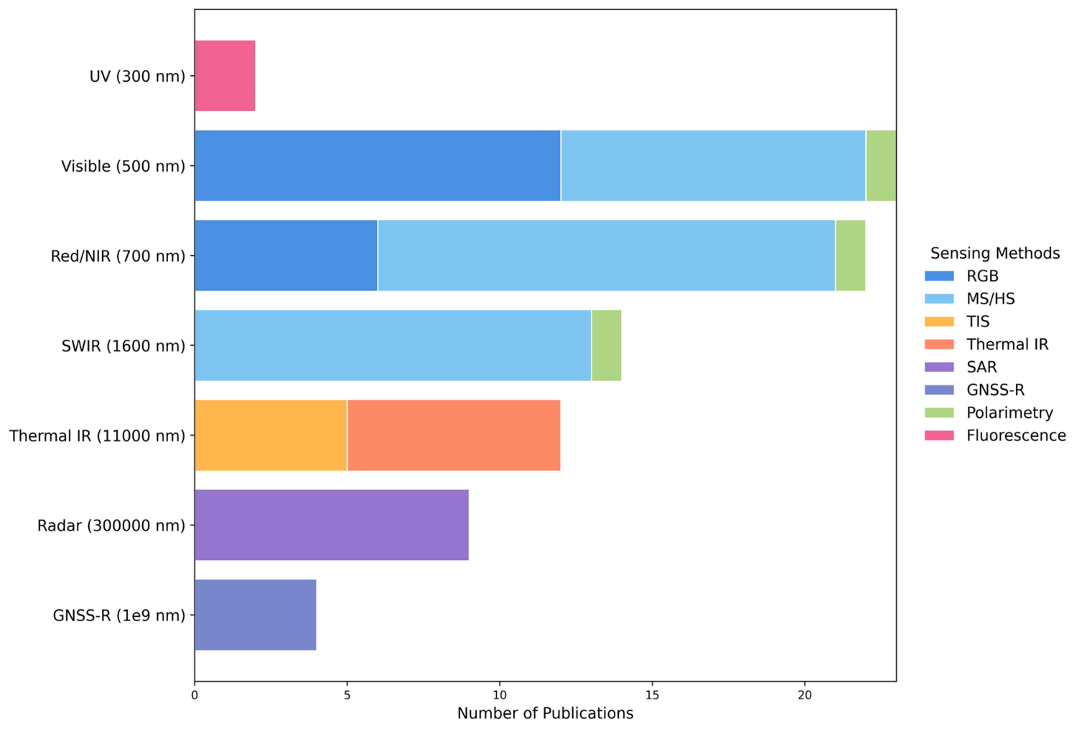
Figure 3. Number of publications applying each sensing method for aquatic plastic detection, categorized by spectral range and technique.
The reviewed literature demonstrates a wide range of satellite-based sensing approaches for aquatic plastic detection, whose applicability to NASA’s PACE mission is contingent upon the spectral and observational design of its onboard instruments. VIS–NIR methods (400-900 nm) dominate existing studies and are fully compatible with PACE’s OCI[9-35]. These methods, including multispectral and hyperspectral analyses, are widely used to classify floating macroplastics and plastic aggregates based on distinctive spectral reflectance signatures. Polarimetry and angular reflectance techniques, though currently underutilized, are well aligned with PACE’s dual polarimeters[59-64]. These instruments are expected to significantly improve the discrimination of plastic debris from natural floating materials, especially under challenging conditions such as variable geometries or sun-glint interference. SWIR methods (~900-2,500 nm) have demonstrated strong potential for polymer-specific spectral fingerprinting, but their effectiveness depends on sensor architecture[9-35]. For PACE, the inclusion of nine discrete SWIR bands enables partial support for these methods, although with less spectral continuity compared to missions like PRISMA or EnMAP. Similarly, ultraviolet (UV)-fluorescence techniques for detecting co-occurring organic matter, along with bio-optical proxies such as CDOM, Chl a, and SSC, fall well within PACE’s measurement capabilities[8,36-42]. Given PACE’s design for high-fidelity ocean color sensing, it is particularly well-suited to these approaches, which build on spectral features routinely used in marine biogeochemistry and water quality monitoring. Conversely, TIR (~11,000 nm), Radar, and GNSS-R, which rely on fundamentally different modalities such as thermal emissivity or active backscatter, are incompatible with PACE’s passive, optical-only design[36-42].
Post-hoc PACE design suitability analysis through comparative studies with other satellites
This study conducts a post-hoc design suitability analysis to retrospectively assess the potential effectiveness of NASA’s PACE mission for monitoring aquatic plastic pollution, drawing comparative insights from an analysis of past satellite-based and proximal sensing studies that employed a variety of sensor platforms and spectral strategies. Following the established methodological framework, ten representative studies published between 2020 and 2024 were evaluated for their relevance and applicability to NASA’s PACE mission [Table 2][14,15,24,30,31,34,77-82]. The studies were selected based on diversity in spectral range, sensor design, and methodological relevance. Each study was analyzed with respect to sensor characteristics, detection context, limitations, and projected transferability to PACE. The reviewed literature encompassed a diverse range of sensor types, including high-resolution multispectral systems (e.g., MSI, OLI, WorldView-3)[14,15,24,30,31,77-81], hyperspectral platforms (e.g., PRISMA, laboratory simulations)[34], SAR systems (e.g., Sentinel-1)[78], and experimental optical configurations such as fluorescence-induced multispectral cameras (e.g., FIMAP)[82,83]. These studies applied diverse detection strategies, including direct reflectance analysis, spectral indices, sub-pixel unmixing, polarimetric measurements, ML models, and bio-optical proxies. While most optical and hyperspectral approaches showed high methodological transferability to PACE - particularly where VNIR-SWIR ranges or polarization sensitivity were employed - radar- and fluorescence-based systems were deemed conceptually informative but not directly transferable due to PACE’s passive, non-excitation, non-microwave sensor design. Across the literature, common limitations were noted, including spatial resolution trade-offs, challenges in atmospheric correction, and reliance on proxies. Nevertheless, PACE’s hyperspectral and polarimetric instrumentation was consistently identified as offering significant potential to enhance spectral discrimination, reduce false positives, and enable more nuanced detection of plastics in complex aquatic environments. The final column of Table 2 provides a qualitative ordinal ranking (High, Moderate, Low, Not Applicable, or Conceptually Informative) of methodological transferability, reflecting the degree of spectral and design compatibility with PACE. Not Applicable indicates a fundamental incompatibility (e.g., reliance on radar or fluorescence-only systems outside PACE’s operational scope), whereas “Conceptually Informative” denotes approaches that, while not directly transferable, offer valuable principles for future sensor development or integration strategies. Overall, the majority of the evaluated studies demonstrated high methodological and spectral compatibility with PACE, particularly those leveraging multispectral and hyperspectral reflectance strategies within the VNIR-SWIR range. While radar- and fluorescence-based approaches fall outside PACE’s direct operational scope, they still offered valuable conceptual insights for future remote sensing development. These findings underscore PACE’s strong potential for translational application in aquatic plastic detection, with current research trajectories closely aligned with its design capabilities.
Projected transferability of satellite sensor-based plastic detection approaches to NASA’s PACE mission
| Study/satellite | Sensor type and wavelengths | Key design features | Plastic detection context | Reported limitations | Comparative implication for PACE | Projected transferability to PACE |
| Guffogg et al., 2024 (WorldView-3)[77] | WorldView-3; multispectral including SWIR | Very high spatial resolution (< 0.5 m); includes two SWIR bands (SWIR-2 & 4); capable of sub-pixel analysis | Plastic targets (simulating beached debris) tested on a sand spit; validated new BPDI index against other plastic and hydrocarbon indices | High-resolution commercial satellite data are expensive; sub-pixel detection remains challenging below ~30% plastic cover; field-based deployments not fully representative of real-world conditions | PACE’s hyperspectral capability may improve spectral discrimination of plastics, but its lower spatial resolution could limit effectiveness on beaches unless sub-pixel mixing approaches are enhanced | High |
| de Fockert et al., 2024 (Hydrodynamic test facility)[78] | Microwave (X and Ku bands, VV polarization); optical (visible-infrared spectral and polarization properties) | Controlled facility tests; multisensor comparison; detection threshold ≥ 1 item/m2 or 1-10 g/m2 | Detection of floating plastic litter in simulated ocean waves | Sensitive to plastic type/concentration; scalability to real-world conditions not yet fully validated | PACE’s global coverage and spectral resolution may enhance detection sensitivity and applicability to natural environments | Conceptually informative |
| Park et al., 2021 (WorldView-3)[31] | Optical (8 bands, very high spatial resolution, top-of-atmosphere reflectance) | Direct and proxy-based detection; anomaly computation; true-color composites; referenced The Ocean Cleanup’s System 001 | Floating plastic litter in the Great Pacific Garbage Patch | Sensitivity limited by reflectance anomalies; not fully operational without ground-truthing; atmospheric conditions may influence anomaly signal | PACE’s hyperspectral data and global ocean color monitoring offer broader spectral coverage, making proxy detection more robust and operationally scalable | High |
| Garaba and Harmel, 2022 (Simulated Sentinel-2, Sentinel-3, WorldView-3)[30] | Hyperspectral lab reflectance + full radiative transfer simulations to TOA signal (VNIR to SWIR) | Lab-controlled turbidity & depth tests; simulation of TOA signal across missions; analysis of submerged plastic signatures | Submerged macroplastic litter under different turbidity and depth conditions | Sentinel-3’s narrow bands not beneficial; aerosol adjacency effects complex; detection limited to ~1 m depth; atmospheric correction essential | PACE’s full spectral characterization and sensitivity to water constituents may improve submerged plastic retrieval, particularly in NIR/SWIR bands | High |
| Biermann et al., 2020 (Sentinel-2 Naïve Bayes ML algorithm)[14,15]. | Multispectral [13 bands, key: Red (665 nm), NIR (842 nm), SWIR (1,610 nm)] | FDI using red, NIR, and SWIR bands to separate plastics from organic material and water | Floating plastic patches in coastal waters, especially near major rivers | Dependence on cloud-free imagery; low contrast for small or submerged debris; water turbidity may mask plastics | PACE covers the same critical bands (Red, NIR, SWIR) but at higher spectral resolution, enhancing plastic discrimination and potentially detecting submerged or mixed debris | High |
| Mohsen et al., 2023 (Sentinel-1, Sentinel-2, PlanetScope and xAI)[24] | Optical (S-2, PlanetScope); SAR (S-1) | MLP model + SHAP; SSC used as proxy for MPs; hydrological phase evaluation | Riverine MP detection in the Tisza River using direct band analysis and SSC proxy | Low direct detection accuracy (R2 ≤ 0.2); improved during floods; Sentinel-1 performed poorly | PACE’s hyperspectral and polarimetric data may improve model explainability and accuracy, especially when integrated with hydrologically informed proxies such as SSC | High |
| ESA, 2023 (Laboratory Polarimetric Measurements)[79] | Hyperspectral radiance & polarized reflectance (400-1,000 nm); DoLP, AoLP | Multi-angle polarization measurements; dry vs. wet, floating vs. submerged; texture, color, and illumination analysis | Floating and submerged macroplastics (e.g. HDPE, PET, LDPE) in controlled water tanks | Detection drops with turbidity and depth; DoLP signals vary with sun and camera angle; RGB data alone insufficient | PACE’s polarimeters (e.g., SPEXone, HARP2) can utilize DoLP/AoLP signals for improved plastic characterization, particularly in multi-angle sun-glint conditions | High |
| Taggio et al., 2022 (PRISMA and ML)[34] | Hyperspectral (239 bands; 400-2,500 nm), PAN band (5 m) | Combined unsupervised (K-Means) and supervised (LGBM) ML on pan-sharpened images | Controlled detection of HDPE, PET, PS plastics in coastal waters of Greece | Limited sample size; 5 m resolution required pan-sharpening; not yet operationally scalable | PACE can build on PRISMA’s hyperspectral strengths, but requires further algorithmic tuning, spatial enhancement, and training datasets for operational ML performance | High |
| Cózar et al., 2024 (Sentinel-2)[80] | MSI (VNIR, SWIR) | 10-60 m resolution; IR spectral index; contextual filtering to detect LWs | Detection of meter-scale LWs in the Mediterranean as proxies for floating plastics | High detection threshold (~20% surface cover); proxy not plastic-specific; sub-pixel ambiguity | PACE’s hyperspectral and polarimetric data may enhance material differentiation and reduce false positives in LW detection and spectral unmixing | High |
| Ho and Feng, 2025 (FIMAP - Non-satellite)[82] | Fluorescence imaging platform with 5 excitation wavelengths (UV–blue) and 4 optical filters (emission bands) | Lab-based retrofitted multispectral imaging system (FIMAP) detecting Nile Red-stained MPs with robust segmentation and clustering (K-means, color coordinates) | Accurate detection and classification of ten polymers (HDPE, LDPE, PP, PS, EPS, ABS, PVC, PC, PET, PA); high-throughput lab screening | Not satellite-based; limited to lab/proximal sensing; fluorescence attenuates in water, lower accuracy for small MPs, infeasible for remote detection without excitation | Though not satellite-compatible, the study presents conceptually valuable approaches (e.g., fluorescence excitation and clustering) for future MP detection with enhanced spectral specificity | Not applicable but conceptually informative |
Strengths, Weaknesses, Opportunities, and Constraints analysis of satellite sensing methods for plastic pollution detection (with PACE integration)
This section applies a modified SWOT framework, termed Strengths, Weaknesses, Opportunities, and Constraints (SWOC), to evaluate satellite sensing methods for plastic pollution detection. The framework incorporates design features from NASA’s PACE mission. Unlike the SWOT model, SWOC replaces the “Threats” with “Constraints” to emphasize the practical and methodological limitations that affect the application of satellite remote sensing in this context.
Building on the post-hoc transferability analysis, which established the alignment between PACE’s sensor architecture and existing satellite-based plastic pollution detection approaches, a higher-order analysis matrix was developed to assess the broader sensing ecosystem. Contemporary studies reveal substantial methodological or spectral compatibility with PACE, especially concerning the use of VNIR–SWIR bands and sub-pixel reflectance techniques. However, it is equally critical to evaluate both the sensors and the methods for their long-term operational robustness, technical constraints, and readiness to support PACE’s global mission profile.
To this end, a second-tier synthesis was conducted to organize the sensing modality landscape within the SWOC framework. The analysis, summarized in Table 3, evaluates major sensing strategies (e.g., visible/NIR, SWIR, radar, polarimetry, fluorescence, thermal IR, and bio-optical proxies) across design features, detection approaches, and adaptability to PACE. The goal is to move beyond one-to-one transferability toward a strategic, system-level understanding of each method’s position. The SWOC analysis underscores enduring strengths, such as the ubiquity of VIS–NIR data and SWIR’s ability to differentiate plastic materials, as well as underutilized polarimetric observations that can enhance surface reflectance accuracy. At the same time, it identifies persistent weaknesses and constraints, including coarse spatial resolution, sensitivity to atmospheric interference, the inferential nature of proxy-based methods, calibration challenges, and the absence of induced emission capabilities for detecting submerged plastic debris.
SWOC analysis of satellite sensing methods for aquatic plastic pollution detection in relation to NASA’s PACE mission
| Sensing method | Strengths | Weaknesses | Opportunities | Constraints |
| Visible to NIR (400-900 nm) | - Broad data availability from legacy missions (Sentinel-2, Landsat-8, WorldView-3) - Supports RGB, multispectral & hyperspectral analyses | - Limited specificity for plastics - Susceptible to cloud/turbidity interference - Moderate spatial resolution | - Enhanced detection with PACE’s fine spectral resolution - Continuity across missions ensures baseline comparability | - Oversaturation of similar datasets may limit novel insights - Sensor degradation over time - Persistent atmospheric interference |
| SWIR (~900-1,600 nm) | - Polymer differentiation power - Reduced spectral confusion with natural materials | - Weak water-leaving reflectance - Limited sensitivity to submerged or small debris - Less frequent acquisitions | - Cross-validation with PACE hyperspectral VIS-NIR data - Potential of future SWIR sensors with improved SNR over water | - Poor performance in high absorption water - Instruments are often expensive and have low revisit rates |
| TIR (~11,000 nm) | - Enables temperature-based plastic detection - Useful for identifying temperature anomalies - Potential for nighttime observations | - Coarse spatial resolution - Low SNR over water - Limited documentation in literature | - Fusion with PACE angular/polarimetric data for diel/diurnal analyses - Complementary for characterizing thermophysical properties of plastic debris | - Unlikely to serve as a standalone solution - Strong atmospheric attenuation and high energy demands |
| Radar/GNSS-R | - Operates in all-weather, day/night conditions - Penetrates clouds, haze, and turbid water - Adds value for surface roughness classification | - Indirect detection - Ambiguous signals for plastics - Complex data interpretation | - Synergistic use with PACE could enhance detection in cloud-prone zones - AI models may improve radar signal interpretation for debris | - High risk of misclassification without optical confirmation - Requires substantial ground-truth validation - Interpretation remains complex |
| Polarimetry & angular observations | - Sensitive to surface roughness and material anisotropy - Can discriminate plastics under different sun-viewing angles | - Limited availability of legacy global datasets - Requires complex calibration and modeling | - PACE polarimetric sensors (HARP2, SPEXone) advance detection physics - Enables reflectance correction in sun glint and high-angle conditions | - Calibration-intensive methods - Potential algorithmic limitations without sufficient training data |
| Fluorescence & DOM-based techniques | - Detects co-occurring organic matter - Provides insights into plastic degradation and biofouling processes | - Few operational studies - Requires ancillary data - Weak standalone detection capability | - Integration with PACE’s CDOM & fluorescence bands - Informative for lifecycle and ecological impact assessments | - Difficult to scale globally - Spectral overlap with natural CDOM signals reduces specificity |
| Bio-optical proxies (Chl a, SSC) | - Well-established for identifying gyres/frontal zones - High temporal resolution from ocean color missions - Widely accessible through satellite products - Helps locate convergence zones (e.g., river mouths, gyres) where plastics accumulate | - Indirect and probabilistic - does not confirm plastic presence - Confounded by environmental variability | - PACE’s biogeochemical focus supports high-fidelity proxy generation - Useful for predicting hotspots to guide targeted monitoring | - Risk of overreliance on indirect correlations, leading to false positives - Lacks specificity without corroborative reflectance-based evidence - Requires improved validation of proxy-to-plastic relationships |
Ultimately, this SWOC framework complements earlier findings by pivoting the discussion from mere methodological compatibility toward a more qualitative assessment. It identifies avenues where PACE’s hyperspectral and polarimetric strengths can support plastic pollution detection, while also recognizing the practical and systemic limitations that must be addressed to achieve global, operational monitoring of aquatic plastic pollution. This approach establishes a roadmap for leveraging PACE as a sensor-model fusion platform that integrates multiple data streams and fosters the next generation of remote sensing solutions for plastic pollution surveillance.
DISCUSSION
NASA’s PACE mission introduces a next-generation sensor architecture that directly addresses long-standing limitations of legacy EO platforms - such as coarse spectral resolution, restricted angular coverage, and vulnerability to sun-glint - through the integration of hyperspectral imaging, polarimetric sensitivity, and multi-angle viewing geometry[84]. These capabilities provide new opportunities for detecting, characterizing, and monitoring plastic pollution in aquatic environments. The integration of spectral, angular, and polarimetric dimensions offers substantial gains over traditional VNIR–SWIR reflectance approaches, enhancing the precision and robustness of plastic detection in complex aquatic environments[84]. The hyperspectral OCI enables fine spectral discrimination of plastics from natural floating matter by capturing narrowband reflectance features in the VNIR and SWIR regions, features previously only available from airborne or research satellites such as PRISMA and EnMAP[81]. HARP2 and SPEXone polarimetry add a new dimension of information via DoLP and AoLP, improving material classification, sun-glint correction, and surface roughness inference - dimensions that remain underexplored in plastic detection[79]. Bio-optical proxy algorithms that exploit PACE’s ability to retrieve Chl a, SSC, and CDOM further support proxy-based inference models, helping predict likely plastic accumulation zones via environmental co-occurrence patterns[85]. With near-daily global coverage, PACE also enables the tracking of dynamic plastic flows in gyres, rivers, and estuaries, providing consistent temporal resolution at a global scale[86].
Despite these advancements, PACE is not without constraints. The mission’s spatial resolution (e.g., ~1 km for OCI) is coarse relative to many plastic aggregation features, such as narrow litter windrows, riverine inputs, or shoreline accumulations[86]. Critics argue that this resolution is insufficient to spectroscopically resolve microplastics, given their small particle sizes. However, this concern is counterbalanced by PACE’s design for phytoplankton detection, including diatoms, which are often smaller than aggregated microplastic particles[87]. Therefore, detection feasibility depends less on absolute particle size than on concentration, spectral distinctiveness, and aggregation behavior. A critical unknown remains the sensor’s limit of detection (LoD) - whether the optical signal of microplastics, especially at low concentrations or in optically complex waters, can rise above the noise threshold is still an open, testable question.
Persistent cloud cover and atmospheric scattering may further obscure observations, and the absence of active fluorescence detection precludes direct identification of some microplastic signals[86,87]. However, these limitations can be mitigated through targeted integration with complementary satellite systems, forming a resilient, multi-modal detection framework that extends PACE’s capabilities while preserving its spectral and polarimetric advantages [Table 2]. Multisensor fusion approaches that combine PACE data with higher-resolution platforms such as WorldView-3 or Sentinel-2 can address spatial limitations by jointly leveraging spectral and spatial information. Similarly, incorporating cloud-penetrating radar sensors (e.g., Sentinel-1 SAR) into fusion pipelines supports observation continuity under suboptimal atmospheric conditions, thereby improving the robustness of spaceborne plastic detection[88].
Even with such system-level enhancements, fundamental physical constraints remain, particularly in the SWIR range. PACE bands near 1,250 and 1,615 nm coincide with regions of strong water absorption, where attenuation coefficients reach ~130 and 700 m-1, respectively[89]. These absorption troughs severely degrade signal fidelity, especially for submerged or partially submerged debris, restricting detection largely to dry or surface-floating plastics. Recent studies [Hu (2021)[89] and Kremezi et al. (2021)[35]] emphasize two intertwined limitations: (1) plastics exhibit inherently low reflectance in the region compared to the NIR; and (2) strong water absorption in the SWIR further suppresses even modest reflectance signals. For example, at 1.2 µm, a plastic object submerged just 1 cm below the surface can experience a 14-fold signal drop, while at 1.6 µm, attenuation exceeds a factor of one million. In contrast, at 765 nm (NIR), the same submersion reduces reflectance by merely 6%, underscoring the comparative utility of the VNIR spectrum for aquatic plastic detection.
These spectral constraints are exacerbated by the mixed pixel effect, where surrounding water smooths the reflectance profile and obscures plastic-specific features, particularly at coarser resolutions or in optically complex waters. Consequently, even surface-floating plastics may become spectrally indistinct in the SWIR, especially under moderate turbidity or cloud-shadow conditions. Thus, VNIR bands emerge as the most reliable spectral window for spaceborne plastic detection. SWIR-VNIR-based indices such as the floating algae index (FAI), alternative FAI (AFAI), plastic index (PI), and floating debris index (FDI) aim to amplify contrast between floating plastic and surrounding water. While these indices may sacrifice some fine-scale sensitivity due to mixed pixel effects and co-registration noise, they remain effective for mitigating SNR degradation and spectral attenuation, providing a pragmatic pathway for PACE-enabled monitoring strategies.
Beyond its spectral range, PACE offers an analytical spectroscopy advantage through high spectral resolution and dense band sampling, particularly across the UV–VNIR. This granularity enables advanced hyperspectral unmixing techniques capable of isolating weak plastic signatures from water-dominated backgrounds. Approaches such as linear spectral mixture analysis (LSMA), endmember extraction, and matched filtering can deconvolve composite signals within mixed pixels - a particularly relevant challenge in coastal and estuarine environments where plastics often co-occur with organic debris and suspended sediments[90-92].
The principal constraint of PACE is its inability to directly observe submerged, benthic, or sediment-incorporated plastic debris due to the optical penetration limits of passive remote sensing. However, this does not preclude alternative detection pathways[93]. PACE’s advanced hyperspectral resolution and biogeochemical sensitivity offer a unique opportunity to exploit indirect indicators such as Chl a, CDOM, and SSC as bio-optical proxies for inferring microplastic presence and behavior in dynamic marine environments[24]. Used in combination with in situ measurements, ML models, and physics-informed frameworks, these proxies support the reconstruction and prediction of microplastic distributions even beyond PACE’s direct optical reach[94].
This proxy-based approach demands high data fidelity and rigorous algorithm development and validation, but it provides a scientifically robust means of mitigating the blind spots of spaceborne sensing. This rationale lies in the fact that the transport and dispersion of microplastics, plankton, sediments, and dissolved materials are governed by fluid dynamics, producing spatial and temporal patterns that are often physically predictable[95]. PACE’s relatively low data latency (6-12 h on average) further enhances operational value, enabling near-real-time monitoring, daily modeling, time-sensitive field campaigns, and emergency response[86]. This positions PACE not only as an observational platform but also as a potential enabler of dynamic, data-driven plastic pollution mitigation strategies on a global scale.
In the SWIR, where water absorption is high and plastic signals are most attenuated, differential reflectance techniques also hold promise. Derivative spectroscopy and continuum removal applied to narrowband pairs (e.g., 1,250 vs. 1,251 nm or 1,615 vs. 1,616 nm) may enhance the detection of subtle, plastic-specific absorption features otherwise masked by water. Similarly, modeling and subtracting water’s absorption curves can reveal residual reflectance anomalies, providing indirect evidence of floating or near-surface plastic materials.
Finally, PACE’s hyperspectral architecture supports adaptive detection algorithms optimized to discriminate plastics from spectrally similar materials such as algae, Sargassum, or emulsified oil. Key spectral features - including the chlorophyll absorption at 665 nm, atmospheric oxygen absorption at 754-765 nm, and the high-contrast region at 865 nm - serve as anchor points for advanced classification techniques such as spectral angle mapping (SAM) and custom index construction. Collectively, PACE’s flexible band selection and fine-scale sensitivity mark a significant step forward in algorithmic plastic detection, enabling the differentiation of anthropogenic debris from natural marine constituents with greater confidence and precision.
OPPORTUNITIES, LIMITATIONS, AND RECOMMENDATIONS
Building on the discussion, a structured roadmap is proposed for advancing PACE-enabled aquatic plastic monitoring, organized into short-, medium-, and long-term priorities. This roadmap highlights opportunities, limitations, and recommendations that directly address the identified challenges.
Short-term (1-3 years): high feasibility, immediate impact
▪ Error Quantification Frameworks (High feasibility, high urgency): Develop standardized protocols for evaluating Type I and Type II errors in plastic classification models, including the creation of match-up datasets with ground-truth measurements[82].
▪ Multi-scale Field Validation (High feasibility, moderate investment): Conduct coordinated validation campaigns across diverse aquatic environments, including deltas, estuaries, and open-ocean hotspots, to calibrate hyperspectral and polarimetric retrieval algorithms.
▪ Open-Source AI Toolkits (High feasibility): Deploy cloud-based, physics-informed AI pipelines for plastic detection to promote global participation and reproducibility.
Medium-term (3-6 years): moderate feasibility, strategic investment needed
▪ Polymer-Specific Discrimination in Optically Complex Waters (Medium feasibility): Advance algorithms capable of distinguishing plastics from organic debris and other confounding materials in turbid coastal waters.
▪ Co-pollutant Proxy Monitoring (Medium feasibility): Establish proof-of-concept studies linking satellite-detected plastics with co-transported pollutants (e.g., PFASs, PCBs, PAHs)[96,97].
▪ Cross-Sensor Integration (High feasibility): Combine PACE data with other EO platforms (e.g., Sentinel-2, Landsat 9) for improved spatial-temporal coverage.
Long-term (6+ years): lower feasibility, transformative potential
▪ Purpose-Built Aquatic Plastic Sensor (High investment, high impact): Following the call by Martínez-Vicente and Cózar, design a dedicated satellite mission with enhanced spectral sensitivity, microwave interferometry, and frequent revisit times to detect plastics under low SNR conditions[80,98,99].
▪ Integration into Aquatic Carbon Budgets (Medium feasibility): Quantify the role of plastics in carbon flux dynamics at a global scale[100].
▪ Sub-surface Plastic Detection (Lower feasibility): Develop active sensing or data fusion techniques to infer submerged macroplastics and microplastics from surface observations.
CONCLUSION
This study highlights the design capabilities of NASA’s PACE mission - particularly its hyperspectral imaging and multi-angle polarimetric sensing - and explores their potential application for monitoring waterborne plastic pollution, including floating microplastics. However, the mission’s spatial, spectral, and contextual limitations underscore the importance of integrating PACE with complementary satellite observations, in situ validation, and advanced ML methods. Addressing these limitations through cross-sensor capabilities, robust algorithm development, and coordinated ground validation efforts will be critical to achieving operational, global-scale monitoring of macro- and microplastics in aquatic systems. The following conclusions are drawn regarding PACE’s potential for monitoring plastic pollution in aquatic environments.
1. Significant strides have been made in monitoring aquatic plastic pollution using legacy satellite missions such as Sentinel-2, WorldView-3, and Landsat-8, despite limitations related to spatial resolution, spectral coverage, and signal interference. Encouragingly, recent advances in hyperspectral EO - particularly through sensors such as EnMAP and PRISMA - are helping to bridge key performance gaps, offering improved spectral granularity for environmental detection tasks. In this context, NASA’s PACE mission introduces transformative capabilities. While its instruments, namely OCI, HARP2, and SPEXone, have thus far been applied primarily to bio-optical parameters such as Chl a, SSC, and CDOM, this study evaluates their potential translatability to plastic pollution monitoring. The findings suggest that PACE’s high spectral resolution and advanced polarimetric sensitivity hold considerable promise for detecting macroplastic and surface microplastic aggregations. Furthermore, the paper examines the challenge of signal attenuation in the SWIR domain - a major constraint for plastic detection - and discusses plausible mitigation strategies, including sensor fusion and spectral de-noising. Collectively, these insights position PACE as a pivotal asset within the evolving remote sensing toolkit for global plastic pollution surveillance.
2. Remote detection of marine macro- and microplastics remains highly constrained due to their extremely weak signals, which are typically indistinguishable from sensor noise. However, large accumulations of macro- or microplastics and other debris can be reliably identified and distinguished from floating vegetation, provided that their sub-pixel coverage exceeds certain thresholds and the sensor achieves sufficiently high SNR. Detectability is further enhanced when advanced techniques such as polarimetry (as in PACE) and microwave-based water surface topology measurements are employed.
Accordingly, further intensive applied research in this domain is recommended. In addition, the development of a purpose-built satellite sensor dedicated to aquatic plastic monitoring is advocated, drawing on the architectural and spectral design principles of NASA’s PACE mission, which was originally developed for ocean color observations.
DECLARATIONS
Authors’ contributions
The author contributed solely to the article.
Availability of data and materials
Not applicable.
Financial support and sponsorship
None.
Conflicts of interest
The author declared that there are no conflicts of interest.
Ethical approval and consent to participate
Not applicable.
Consent for publication
Not applicable.
Copyright
© The Author(s) 2025.
REFERENCES
1. Ritchie, H.; Samborska, V.; Roser, M. Plastic pollution. https://ourworldindata.org/plastic-pollution. (accessed 5 Sep 2025).
2. Rieger, N.; Olmedo, E.; Thiel, M.; et al. Seasonal hotspots of beach litter in the North-East Atlantic linked to aquaculture and river runoff. Commun. Earth. Environ. 2024, 5, 1913.
3. Ostle, C.; Thompson, R. C.; Broughton, D.; Gregory, L.; Wootton, M.; Johns, D. G. The rise in ocean plastics evidenced from a 60-year time series. Nat. Commun. 2019, 10, 1622.
4. Kaandorp, M. L. A.; Lobelle, D.; Kehl, C.; Dijkstra, H. A.; van Sebille, E. Global mass of buoyant marine plastics dominated by large long-lived debris. Nat. Geosci. 2023, 16, 689-94.
5. Prata, J. C. A One Health perspective on water contaminants. Water. Emerg. Contam. Nanoplastics. 2022, 1, 15.
6. Jin, X.; Li, Z.; Peñuelas, J.; et al. Quantitative assessment on the distribution patterns of microplastics in global inland waters. Commun. Earth. Environ. 2025, 6, 2320.
7. Galgani, F.; Brien, A. S.; Weis, J.; et al. Are litter, plastic and microplastic quantities increasing in the ocean? Micropl. Nanopl. 2021, 1, 2.
8. Gerigny, O.; Blanco, G.; Lips, U.; et al. Comparative analysis of microplastics detection methods applied to marine sediments: a case study in the Bay of Marseille. Mar. Pollut. Bull. 2024, 207, 116787.
9. Topouzelis, K.; Papageorgiou, D.; Karagaitanakis, A.; Papakonstantinou, A.; Arias Ballesteros, M. Remote sensing of sea surface artificial floating plastic targets with Sentinel-2 and Unmanned Aerial Systems (Plastic Litter Project 2019). Remote. Sens. 2020, 12, 2013.
10. Papageorgiou, D.; Topouzelis, K.; Suaria, G.; Aliani, S.; Corradi, P. Sentinel-2 detection of floating marine litter targets with partial spectral unmixing and spectral comparison with other floating materials (Plastic Litter Project 2021). Remote. Sens. 2022, 14, 5997.
11. Themistocleous, K.; Papoutsa, C.; Michaelides, S.; Hadjimitsis, D. Investigating detection of floating plastic litter from space using Sentinel-2 imagery. Remote. Sens. 2020, 12, 2648.
12. Ciappa, A. C. Marine plastic litter detection offshore Hawai’i by Sentinel-2. Mar. Pollut. Bull. 2021, 168, 112457.
13. Zhu, X.; Lu, Y.; Dou, C.; Ju, W. Improving sea surface floating matter identification from Sentinel-2 MSI imagery using optical radiative simulation of neighborhood difference. Opt. Express. 2023, 31, 27612-20.
14. Biermann, L.; Clewley, D.; Martinez-Vicente, V.; Topouzelis, K. Finding plastic patches in coastal waters using optical satellite data. Sci. Rep. 2020, 10, 5364.
15. Biermann, L.; Clewley, D.; Martinez-Vicente, V.; Topouzelis, K. Detecting and identifying floating plastic debris in coastal waters using Sentinel-2 Earth observation data. In EGU General Assembly 2020. 2020; Paper EGU2020-19145.
16. Wu, C.; Chen, Z.; An, C. A novel spectral index for detecting large plastic accumulations using Sentinel-2 imagery. SSRN 2025.
17. Valente, A.; Castanho, E.; Giusti, A.; Pinelo, J.; Silva, P. An open-source data pipeline framework to detect floating marine plastic litter using Sentinel-2 imagery and machine learning. In IGARSS 2023 - 2023 IEEE International Geoscience and Remote Sensing Symposium, Pasadena, USA. Jul 16-21, 2023. IEEE; 2023. pp. 4108-11.
18. Jayabhavani, G. N.; Muthu, T. Floating litter detection at the estuary of Puducherry using Sentinel-2 data and machine learning model. Reg. Stud. Mar. Sci. 2024, 77, 103686.
19. Sannigrahi, S.; Basu, B.; Basu, A. S.; Pilla, F. Development of automated marine floating plastic detection system using Sentinel-2 imagery and machine learning models. Mar. Pollut. Bull. 2022, 178, 113527.
20. Basu, B.; Sannigrahi, S.; Sarkar Basu, A.; Pilla, F. Development of novel classification algorithms for detection of floating plastic debris in coastal waterbodies using multispectral Sentinel-2 remote sensing imagery. Remote. Sens. 2021, 13, 1598.
21. Booth, H.; Ma, W.; Karakuş, O. High-precision density mapping of marine debris and floating plastics via satellite imagery. Sci. Rep. 2023, 13, 6822.
22. Jamali, A.; Mahdianpari, M. A cloud-based framework for large-scale monitoring of ocean plastics using multi-spectral satellite imagery and generative adversarial network. Water 2021, 13, 2553.
23. Priyadarshini, R.; Varun, A.; Sowmya, K. S. Automated marine debris detection from Sentinel-2 satellite imagery. In 2024 IEEE Space, Aerospace and Defence Conference (SPACE), Bangalore, India. Jul 22-23, 2024. IEEE; 2024. pp. 454-8.
24. Mohsen, A.; Kiss, T.; Kovács, F. Machine learning-based detection and mapping of riverine litter utilizing Sentinel-2 imagery. Environ. Sci. Pollut. Res. Int. 2023, 30, 67742-57.
25. Acuña-Ruz, T.; Uribe, D.; Taylor, R.; et al. Anthropogenic marine debris over beaches: spectral characterization for remote sensing applications. Remote. Sens. Environ. 2018, 217, 309-22.
26. Zhou, S.; Kuester, T.; Bochow, M.; Bohn, N.; Brell, M.; Kaufmann, H. A knowledge-based, validated classifier for the identification of aliphatic and aromatic plastics by Worldview-3 satellite data. Remote. Sens. Environ. 2021, 264, 112598.
27. Tasseron, P.; van Emmerik, T.; Peller, J.; Schreyers, L.; Biermann, L. Advancing floating macroplastic detection from space using hyperspectral imagery. Remote. Sens. 2021, 13, 2335.
28. Biermann, L.; Schreyers, L.; van Emmerik, T.; Bui, T. K.; Ling, Y.; Streett, D. Finding riverine plastics in floating plant patches using Worldview-3 satellite imagery. In EGU General Assembly 2022. 2022; Paper EGU22-12856.
29. Jakovljević, G.; Govedarica, M.; Taboada, FÁ. Remote sensing data in mapping plastics at surface water bodies. In FIG Working Week, Hanoi, Vietnam. Apr 22-26, 2019. https://www.fig.net/resources/proceedings/fig_proceedings/fig2019/papers/ts01d/TS01D_jakovljevic_govedarica_et_al_9974.pdf. (accessed 5 Sep 2025).
30. Garaba, S. P.; Harmel, T. Top-of-atmosphere hyper and multispectral signatures of submerged plastic litter with changing water clarity and depth. Opt. Express. 2022, 30, 16553-71.
31. Park, Y. J.; Garaba, S. P.; Sainte-Rose, B. Detecting the Great Pacific Garbage Patch floating plastic litter using WorldView-3 satellite imagery. Opt. Express. 2021, 29, 35288-98.
32. Kikaki, A.; Karantzalos, K.; Power, C. A.; Raitsos, D. E. Remotely sensing the source and transport of marine plastic debris in Bay Islands of Honduras (Caribbean Sea). Remote. Sens. 2020, 12, 1727.
33. Atwood, E. C.; Falcieri, F. M.; Piehl, S.; et al. Coastal accumulation of microplastic particles emitted from the Po River, Northern Italy: comparing remote sensing and hydrodynamic modelling with in situ sample collections. Mar. Pollut. Bull. 2019, 138, 561-74.
34. Taggio, N.; Aiello, A.; Ceriola, G.; et al. A combination of machine learning algorithms for marine plastic litter detection exploiting hyperspectral PRISMA data. Remote. Sens. 2022, 14, 3606.
35. Kremezi, M.; Kristollari, V.; Karathanassi, V.; et al. Pansharpening PRISMA data for marine plastic litter detection using plastic indexes. IEEE. Access. 2021, 9, 61955-71.
36. Salgado-Hernanz, P. M.; Bauzà, J.; Alomar, C.; Compa, M.; Romero, L.; Deudero, S. Assessment of marine litter through remote sensing: recent approaches and future goals. Mar. Pollut. Bull. 2021, 168, 112347.
37. Mukonza, S. S.; Chiang, J. Satellite sensors as an emerging technique for monitoring macro- and microplastics in aquatic ecosystems. Water. Emerg. Contam. Nanoplastics. 2022, 1, 17.
38. Park, S.; Kim, C.; Jeong, S.; et al. Review of remote sensing applicability for monitoring marine microplastics. Korean. J. Remote. Sens. 2022, 38, 835-50.
39. Veettil, B. K.; Hong Quan, N.; Hauser, L. T.; Doan Van, D.; Quang, N. X. Coastal and marine plastic litter monitoring using remote sensing: a review. Estuar. Coast. Shelf. Sci. 2022, 279, 108160.
40. Ma, J.; Ma, R.; Pan, Q.; Liang, X.; Wang, J.; Ni, X. A global review of progress in remote sensing and monitoring of marine pollution. Water 2023, 15, 3491.
41. Goddijn-Murphy, L.; Martínez-Vicente, V.; Dierssen, H. M.; et al. Emerging technologies for remote sensing of floating and submerged plastic litter. Remote. Sens. 2024, 16, 1770.
42. Chabot, D.; Marteinson, S. C. Aerial remote sensing of aquatic microplastic pollution: the state of the science and how to move it forward. Microplastics 2024, 3, 685-95.
43. Dierssen, H. M.; Gierach, M.; Guild, L. S.; et al. Synergies between NASA’s hyperspectral aquatic missions PACE, GLIMR, and SBG: opportunities for new science and applications. J. Geophys. Res. Biogeosci. 2023, 128, e2023JG007574.
44. Frouin, R.; Tan, J. PCA-based atmospheric correction of PACE OCI ocean color imagery. In Active and Passive Remote Sensing of Oceans, Seas, and Lakes. 2025.
45. Vandermeulen, R.; Lance, V.; Otoshi, C.; Riley, K.; Tomlinson, M.; Trinh, R. Plankton, Aerosol, Cloud and ocean Ecosystem (PACE) satellite data for aquaculture and fisheries management. 2025.
46. Frouin, R. J.; Franz, B. A.; Ibrahim, A.; et al. Atmospheric correction of satellite ocean-color imagery during the PACE Era. Front. Earth. Sci. 2019, 7, 145.
47. Jutla, A. S.; Akanda, A. S.; Islam, S. A framework for predicting endemic cholera using satellite derived environmental determinants. Environ. Model. Softw. 2013, 47, 148-58.
48. Engstrom, R.; Hersh, J.; Newhouse, D. Poverty from space: using high resolution satellite imagery for estimating economic well-being. World. Bank. Econ. Rev. 2022, 36, 382-412.
49. Wu, Z.; Zhang, C.; Gu, X.; et al. Deep learning enables satellite-based monitoring of large populations of terrestrial mammals across heterogeneous landscape. Nat. Commun. 2023, 14, 3072.
50. Raynor, J.; Orofino, S.; Costello, C.; McDonald, G.; Mayorga, J.; Sala, E. Little-to-no industrial fishing occurs in fully and highly protected marine areas. Science 2025, 389, 392-5.
51. NASA Applied Remote Sensing Training Program (ARSET). ARSET - Introduction to Plankton, Aerosol, Cloud, Ocean Ecosystem (PACE) hyperspectral observations for water quality monitoring. 2024. https://appliedsciences.nasa.gov/get-involved/training/english/arset-introduction-plankton-aerosol-cloud-ocean-ecosystem-pace. (accessed 5 Sep 2025).
52. Meister, G.; Knuble, J. J.; Bars,
53. Meister, G.; Knuble, J. J.; Gliese, U.; et al. The Ocean Color Instrument (OCI) on the Plankton, Aerosol, Cloud, ocean Ecosystem (PACE) Mission: system design and prelaunch radiometric performance. IEEE. Trans. Geosci. Remote. Sens. 2024, 62, 1-18.
54. Gliese, U.; Rhodes, Z.; Squire, K.; et al. Pulse response of the short-wave infrared detection system of the ocean color instrument for the NASA PACE mission. In Sensors, Systems, and Next-Generation Satellites XXVII. 2023.
55. Lee, S.; Meister, G.; Kitchen, S.; Knuble, J.; Gliese, U.; Bousquet, R. PACE OCI crosstalk characterization based on pre-launch testing. In Sensors, Systems, and Next-Generation Satellites XXVII. 2023.
56. Zibordi, G.; Talone, M.; Voss, K. J.; Johnson, B. C. Impact of spectral resolution of in situ ocean color radiometric data in satellite matchups analyses. Opt. Express. 2017, 25, A798-812.
57. Olyaei, M.; Ebtehaj, A. Uncovering plastic litter spectral signatures: a comparative study of hyperspectral band selection algorithms. Remote. Sens. 2024, 16, 172.
58. Singh, M. K.; Hait, S.; Thakur, A. Hyperspectral imaging-based classification of post-consumer thermoplastics for plastics recycling using artificial neural network. Process. Saf. Environ. Prot. 2023, 179, 593-602.
59. Hasekamp, O. P.; Fu, G.; Rusli, S. P.; et al. Aerosol measurements by SPEXone on the NASA PACE mission: expected retrieval capabilities. J. Quant. Spectrosc. Radiat. Transfer. 2019, 227, 170-84.
60. Rietjens, J.; Campo, J.; Chanumolu, A.; et al. Expected performance and error analysis for SPEXone, a multi-angle channeled spectropolarimeter for the NASA PACE mission. In Polarization Science and Remote Sensing IX. 2019.
61. Smit, J. M.; Rietjens, J. H. H.; van Harten, G.; et al. SPEX airborne spectropolarimeter calibration and performance. Appl. Opt. 2019, 58, 5695-719.
62. Ottaviani, M.; Cairns, B.; Chowdhary, J.; et al. Polarimetric retrievals of surface and cirrus clouds properties in the region affected by the Deepwater Horizon oil spill. Remote. Sens. Environ. 2012, 121, 389-403.
63. Ottaviani, M.; Chowdhary, J.; Cairns, B. Remote sensing of the ocean surface refractive index via short-wave infrared polarimetry. Remote. Sens. Environ. 2019, 221, 14-23.
64. Jamet, C.; Ibrahim, A.; Ahmad, Z.; et al. Going beyond standard ocean color observations: lidar and polarimetry. Front. Mar. Sci. 2019, 6, 251.
65. Arksey, H.; O’malley, L. Scoping studies: towards a methodological framework. Int. J. Soc. Res. Methodol. 2005, 8, 19-32.
66. Paré, G.; Kitsiou, S. Chapter 9 Methods for literature reviews. In: Lau F, Kuziemsky C, Editors. Handbook of eHealth evaluation: an evidence-based approach. University of Victoria; 2017. https://www.ncbi.nlm.nih.gov/books/NBK481583/. (accessed 5 Sep 2025).
67. GIZ. Advances in remote sensing of plastic waste. 2023. https://globalplasticshub.org/technical-resource/10838. (accessed 5 Sep 2025).
68. Maximenko, N.; Corradi, P.; Law, K. L.; et al. Toward the integrated marine debris observing system. Front. Mar. Sci. 2019, 6, 447.
69. Vasudeva, M.; Warrier, A. K.; Kartha, V.; Unnikrishnan, V. Advances in microplastic characterization: spectroscopic techniques and heavy metal adsorption insights. TrAC. Trends. Anal. Chem. 2025, 183, 118111.
70. Wang, J.; Kim, K.; Ofiara, D.; et al. Chapter 25 - Marine debris. In The first global integrated marine assessment: World Ocean Assessment I. Cambridge University Press; 2017. pp. 389-408.
71. Bermúdez, J. R.; Swarzenski, P. W. A microplastic size classification scheme aligned with universal plankton survey methods. MethodsX 2021, 8, 101516.
72. Egger, M.; Schilt, B.; Wolter, H.; et al. Pelagic distribution of plastic debris (> 500 µm) and marine organisms in the upper layer of the North Atlantic Ocean. Sci. Rep. 2022, 12, 13465.
73. Garaba, S. P.; Dierssen, H. M. An airborne remote sensing case study of synthetic hydrocarbon detection using short wave infrared absorption features identified from marine-harvested macro- and microplastics. Remote. Sens. Environ. 2018, 205, 224-35.
74. Castagna, A.; Dierssen, H. M.; Devriese, L. I.; Everaert, G.; Knaeps, E.; Sterckx, S. Evaluation of historic and new detection algorithms for different types of plastics over land and water from hyperspectral data and imagery. Remote. Sens. Environ. 2023, 298, 113834.
75. International Ocean-Colour Coordinating Group (IOCCG). IOCCG Task Force: remote sensing of marine litter and debris. https://ioccg.org/group/marine-litter-debris/. (accessed 5 Sep 2025).
76. European Space Agency (ESA). TPM data help advance plastic litter detection from space. 2023. https://earth.esa.int/eogateway/news/tpm-data-help-advance-plastic-litter-detection-from-space. (accessed 5 Sep 2025).
77. Guffogg, J.; Soto-Berelov, M.; Bellman, C.; Jones, S.; Skidmore, A. Beached plastic debris index; a modern index for detecting plastics on beaches. Mar. Pollut. Bull. 2024, 209, 117124.
78. de Fockert, A.; Eleveld, M. A.; Bakker, W.; et al. Assessing the detection of floating plastic litter with advanced remote sensing technologies in a hydrodynamic test facility. Sci. Rep. 2024, 14, 25902.
79. ESA. Characterization of light polarization properties of virgin and marine-harvested plastic litter toward remote-sensing mapping of ocean plastics. Ocean Plastics Polarization Properties OP3. 2022. https://nebula.esa.int/sites/default/files/neb_study/2676/OP3_400013203720_Executive_Summary_16Dec2022_v2_0.pdf. (accessed 5 Sep 2025).
80. Cózar, A.; Arias, M.; Suaria, G.; et al. Proof of concept for a new sensor to monitor marine litter from space. Nat. Commun. 2024, 15, 4637.
81. Moshtaghi, M.; Knaeps, E.; Sterckx, S.; Garaba, S.; Meire, D. Spectral reflectance of marine macroplastics in the VNIR and SWIR measured in a controlled environment. Sci. Rep. 2021, 11, 5436.
82. Ho, D.; Prabhakar, P.; Karthikeyan, K. G.; Feng, H. Shedding light on the polymer’s identity: microplastic detection and identification through Nile Red staining and multispectral imaging (FIMAP). J. Environ. Chem. Eng. 2025, 13, 117944.
83. Mahmoud, A.; El-Sharkawy, Y. H. Instant plastic waste detection on shores using laser-induced fluorescence and associated hyperspectral imaging. Opt. Quant. Electron. 2024, 56, 6564.
84. Remer, L. A.; Knobelspiesse, K.; Zhai, P.; et al. Retrieving aerosol characteristics from the PACE mission, Part 2: multi-angle and polarimetry. Front. Environ. Sci. 2019, 7, 94.
85. Fronkova, L.; Brayne, R. P.; Ribeiro, J. W.; Cliffen, M.; Beccari, F.; Arnott, J. H. W. Assessing the effect of water on submerged and floating plastic detection using remote sensing and K-means clustering. Remote. Sens. 2024, 16, 4405.
86. Cetinić, I.; Rousseaux, C. S.; Carroll, I. T.; et al. Phytoplankton composition from sPACE: requirements, opportunities, and challenges. Remote. Sens. Environ. 2024, 302, 113964.
87. Schollaert Uz, S.; Kim, G. E.; Mannino, A.; Werdell, P. J.; Tzortziou, M. Developing a community of practice for applied uses of future PACE data to address marine food security challenges. Front. Earth. Sci. 2019, 7, 283.
88. Sellaperumal, P.; Kaliaperumal, R.; Dhanaraju, M.; et al. Time series analysis of Sentinel 1 A SAR data to retrieve annual rice area maps and long-term dynamics of start of season. Sci. Rep. 2025, 15, 8202.
89. Hu, C. Remote detection of marine debris using satellite observations in the visible and near infrared spectral range: challenges and potentials. Remote. Sens. Environ. 2021, 259, 112414.
90. Du, Q.; Chang, C. Linear mixture analysis-based compression for hyperspectral image analysis. IEEE. Trans. Geosci. Remote. Sens. 2004, 42, 875-91.
91. Wang, L.; Bi, Y.; Wang, W.; Li, J. Endmember extraction and abundance estimation algorithm based on double-compressed sampling. Sci. Rep. 2024, 14, 17934.
92. Zuo, C.; Qian, J.; Feng, S.; et al. Deep learning in optical metrology: a review. Light. Sci. Appl. 2022, 11, 39.
93. Jones, D. O. B.; Gates, A. R.; Huvenne, V. A. I.; Phillips, A. B.; Bett, B. J. Autonomous marine environmental monitoring: application in decommissioned oil fields. Sci. Total. Environ. 2019, 668, 835-53.
94. Lou, J.; Liu, B.; Xiong, Y.; Zhang, X.; Yuan, X. Variational autoencoder framework for hyperspectral retrievals (Hyper-VAE) of phytoplankton absorption and chlorophyll a in coastal waters for NASA’s EMIT and PACE missions. IEEE. Trans. Geosci. Remote. Sens. 2025, 63, 1-16.
95. Isachenko, I.; Chubarenko, I. Transport and accumulation of plastic particles on the varying sediment bed cover: open-channel flow experiment. Mar. Pollut. Bull. 2022, 183, 114079.
96. Parashar, N.; Mahanty, B.; Hait, S. Microplastics as carriers of per- and polyfluoroalkyl substances (PFAS) in aquatic environment: interactions and ecotoxicological effects. Water. Emerg. Contam. Nanoplastics. 2023, 3, 15.
97. Mukonza, S. S.; Chaukura, N. Bird’s-eye view of per- and polyfluoroalkyl substances pollution research in the African hydrosphere. npj. Clean. Water. 2025, 8, 495.
98. Martinez-Vicente, V. The need for a dedicated marine plastic litter satellite mission. Nat. Rev. Earth. Environ. 2022, 3, 728-9.
99. Martínez-Vicente, V.; Clark, J. R.; Corradi, P.; et al. Measuring marine plastic debris from space: initial assessment of observation requirements. Remote. Sens. 2019, 11, 2443.
Cite This Article
How to Cite
Download Citation
Export Citation File:
Type of Import
Tips on Downloading Citation
Citation Manager File Format
Type of Import
Direct Import: When the Direct Import option is selected (the default state), a dialogue box will give you the option to Save or Open the downloaded citation data. Choosing Open will either launch your citation manager or give you a choice of applications with which to use the metadata. The Save option saves the file locally for later use.
Indirect Import: When the Indirect Import option is selected, the metadata is displayed and may be copied and pasted as needed.
About This Article
Copyright

Data & Comments
Data
0


Comments
Comments must be written in English. Spam, offensive content, impersonation, and private information will not be permitted. If any comment is reported and identified as inappropriate content by OAE staff, the comment will be removed without notice. If you have any queries or need any help, please contact us at [email protected].